
|


Reference Weather Map |
Current Weather Map |
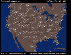
The surface meteorological charts above depict the current surface conditions at chosen sites across North America.
The hourly observations (updated every hour) contain information about surface temperature and dew point temperature in degrees Fahrenheit, sea level pressure, wind speed and direction, cloud cover and type of weather conditions occurring at each surface station during the last hour. The hourly observations link provides detailed information on how to decode and interpret the numbers and symbols at each station.
|
Pressure Maps |
|
surface obs, ir sat |