
|


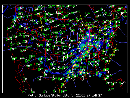
The surface meteorological chart above depicts the current surface conditions at chosen sights across North America. This map, updated shortly after each hour, illustrates the present weather patterns and the location of storm systems over the continental United States.
The hourly observations (updated every hour) contain information about surface temperature and dew point temperature in degrees Fahrenheit, sea level pressure, wind speed and direction, cloud cover, and type of weather conditions occurring at each surface station during the last hour. The hourly observations link provides detailed information on how to decode and interpret the numbers and symbols at each station. The blue contours called isobars and depict areas of High and Low pressure.
In the background, radar reflectivity data depict areas of precipitation occurring during the past hour. The strongest echoes (refer to the color scale) during the warm season indicate areas of intense rain and/or hail, generally associated with deep convection. For more information about the radar data refer to radar images.
The low pressure centers over United States are often referred to as midlatitude cyclones and can be identified as a minimum in the pressure field, and an area of cyclonic circulation of the surface flow. These storm systems are typically characterized by cloud cover in the vicinity of the low pressure center, relatively warm and moist flow with a southerly component ahead of the cold front and colder and drier airmass behind it, as well as areas of precipitation associated with both warm and cold fronts.
|
Contours |
|
obs, isobars, ir sat |