
|


Analysis of the upper levels of a storm are crucial in understanding its behavior. Even in the case of lake effect snow, which is brought about mainly by processes close to the ground, the upper level flow and "dynamics" can give key insights into why the storm developed and how long the storm might persist.
In our case, this is a classic setup for a big LES event. The closed low and unusually cold air aloft allows plenty of time for cold surface winds to blow across the open waters of each lake and produce convective snowbands and snow squalls. The flow about midway through the troposphere (at 500 millibars, or about 5400 meters ~ 18,000 feet) features a deep upper level low pressure centered near Lake Superior on Nov 10, 1996 at 00Z (see below). This upper low is a pool of cold air aloft, and the center of a broad counterclockwise or cyclonic circulation which includes most of the eastern half of the US. In our case, the strongest flow is far away from the upper low center and is denoted as the area of "strong flow and shear zone" on the map below.
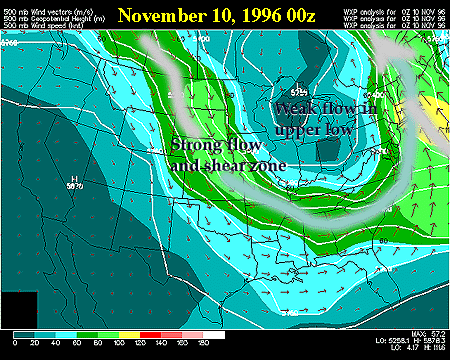
The shear zone, which means that wind speeds are changing rapidly with horizontal distance, is coincident with the "polar front" and can be roughly thought of as a line of strong temperature contrast separating cold polar air from warmer air to the south. The broad gray airstream depicted in the 500mb images roughly shows the axis of the polar jet which is coincident with the polar front and shear zone.
In our storm the upper low, polar front, and polar jet drift slowly north and eastward over the three-day period. Notice, the amplitude of the cyclonic trough relaxes over the three day period. In addition, the trough axis (draw a line from the upper low to the base of the upper trough) also changes its tilt in relation to due north-south or a line of longitude.
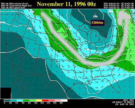
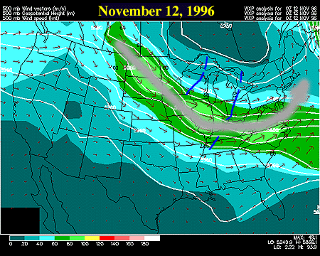
On Saturday evening Nov 10, 1996, the trough axis is tilted from southeast to northwest - this is called a "negative tilt" and suggests the trough is "digging" or deepening which slows its eastward progress. By Monday evening Nov 12, 1996 the trough has taken on a SW to NE orientation or "positive tilt" which helps promote the trough's north and eastward progress and helps to reduce the amplitude or weaken the trough.
The digging of the upper low and its quasi-stationary position during the onset of the storm is very important in analyzing this case. The closed upper level low "sits and spins" which keeps lots of cold air in place over the Great Lakes, encourages rising motions in the atmosphere because of its cyclonic rotation, and also prevents more stable and dryer air from penetrating eastward into the region.
In the final image the dashed blue lines indicate the axes of small waves or disturbances moving through the broader flow. These "shortwaves" are very important to our daily weather in that they encourage low pressures to form at the surface and in general can focus or enhance stormy circulations, such as lake effect snow, in the lower atmosphere. In our case, minor shortwaves pivoted cyclonically around the upper low throughout the duration of the storm. Each shortwave strengthened the LES bands as it moved across the Great Lakes, and also caused the bands to migrate as the low-level steering flow changed in response to the upper shortwave feature. These interactions between the upper and lower atmosphere are discussed in greater detail in the advanced section of this case study.
|
850 mb |
|
Soundings |