
|


On Tuesday evening Nov 12, 1996 the LES continues in NE Ohio. The bands over Lake Erie appear a bit weaker and ragged. The image below indicates that the main Erie band has aligned itself with the shoreline of eastern Lake Erie. Indeed, spotter reports indicated that near-shore locales were receiving heavy snow on Tuesday evening which continued through Wednesday late morning.
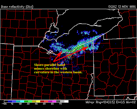
An interesting feature of the bands at this time is the unusual curvature of the LES band from the western basin of Lake Erie into the NE shoreline. This shore-parallel band appears to be roughly mimicing the shoreline in its organization and alignment (although it appears to be shifted downstream some distance). LES bands aligning along a shore are not uncommon, and are thought to be a result of "land breezes" focusing convergence and convection right at the shoreline. However, it is a bit unusual to see bands at mid-lake that recurve to (apparently) shape themselves to the downwind shoreline. In animation (not shown here) this feature persists for some time on Tuesday evening and Wednesday morning, so it is not a transient feature.

By late day Wednesday Nov 13, 1996 the NE Ohio storm is nearly over. Lake squalls continue in earnest in western NY and off of the east end of Lake Ontario snows continued into Thursday evening. The higher reflectivities observed in west central Ohio are a result of an upper level "shortwave" and some "warm air advection" aloft. Much of this snowfall did not reach the ground - the radar signal is best interpreted as a "kicker" wave which is helping to - finally - push the big LES storm east and north. The next section on upper air data will explain why warm aloft might help "kill" a lake effect snowstorm.
|
Nov 12, 1996 |
|
Upper Air Data |