
|


1. Recap of the synoptic and lake effect snowfalls
In short, a potentially severe early season lake effect snowstorm was taking shape. Over time, a consensus of leading criteria for strong lake effect snowfalls in the lee of the Great Lakes has been determined by forecasters and researchers - these include:
- Delta-T between the lake surface and 850 Mb > -17C (-13C for weak lake
effect)
- Little directional wind shear below 700mb (less than 30 degrees of
turning in the weak case)
- Capping inversions no lower than 750 Mb (850mb for weak case)
- Maximum 850 temperatures of -10C (-6C to -9C for weak case).
However, two potential mitigating factors to heavy lake snows were discussed by forecasters on 11/8/96. Especially in the eastern lakes, it would take a good deal of time for winds to align in the lower levels. Good directional shear was likely between the surface and 700 Mb until late on 11/10/96 with modest improvement of the wind alignment forecast in the subsequent 24 hours. More importantly, a negatively tilted trough and closed circulation nearby would slow the advection of cold air aloft and at the surface as isotherms and heights became parallel and the height contours stacked vertically under the spinning upper low. Cold (enough) air would certainly arrive, but perhaps not in time to take advantage of the near steady state cyclonic curvature, flow, and residual moisture hanging back in the Great Lakes.
Finally, little importance was placed on the initial short-wave feature, analyzed on 11/8/96, in terms of sensible weather. This disturbance was thought to be crucial in helping dig and close off the upper level flow, but was not expected to produce significant snowfall or noteworthy surface weather. Forecasters in Buffalo noted that a surface reflection of the upper low would develop in NW PA by the morning of 11/10/96 which would delay the arrival of cold air due to weak warm air advection on the east side of the surface low, and would also keep low level directional wind shear well below the alignment criteria for lake-effect.
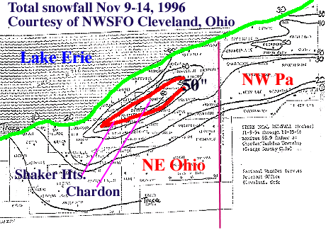
What transpired the next several days in the Great Lakes, was an epic lake-effect snowfall of long duration with snowfall exceeding 70" in isolated cases and widespread snowfalls of 30-50" in the favored snowbelts of all of the lakes. The following summarizes the chronology of the storm:
- Nov. 9 - a.m. A short-wave in the lower lakes give N.
Indiana 3-5" of snow and moves into western Ohio.
- Nov. 9 - p.m.The short-wave intensifies and slows as the
longwave trough closes off and becomes negatively tilted. Northeast Ohio
receives as much as 11-14" of heavy wet snow. Over 70,000 people lose
power
in Lake and Cuyahoga county and widespread tree damage occurs in much of
NE Ohio. Lake effect snow is already becoming widespread in the upper
lakes; Hurley in extreme northeastern Minnesota is receiving very
heavy lake effect snowfall.
- Nov. 10 - a.m. Strong lake effect bands continue in the western
lakes
and begin setting up in the eastern lakes. South of BUF and ERI begin
recording 1-3"/hour accumulations. Thunder and lightning accompany some
of the heavier pulses embedded in the lake effect bands. Widespread
convective snow showers are evident throughout the midwest and Ohio
Valley as the atmosphere becomes increasingly unstable and late fall
sunshine applies some heating to the surface.
- Nov. 10 - p.m. The strong Lake Erie bands shift southward into
NE Ohio. Snowfall in the UP of Michigan exceeds 25" in some locations.
Heavy snows pound the snowbelts west of a ROC to PIT line throughout the
night with widespread reports of over 12" of snowfall.
- Nov. 11 - a.m. Snows continue, but the bands are less
widespread. The convective or Benard type cellular regime returns to the
region. Some forecasters discuss if the Benard cells are interfering with
the banded patterns over the lakes. The Tug Hill Plateau and Lake Ontario
snowbelts start to receive heavy snowfall. Surface temperatures
throughout the lakes are at or below freezing and 850 Mb temperatures
continue to reduce to below -10C throughout the entire region.
- Nov. 11 - p.m. After dark, a clear increase in intensity and
coverage of
the strong lake bands is observed. Snows continue heavily for
most snowbelts. Thunder and lightning is reported for a third night in a
row in NE Ohio.
- Nov. 12 - Nov. 13 The storm slowly winds down. Warm air aloft
and the development of a capping inversion in the western lakes advects
slowly eastward shutting off the heaviest snows. Again on 11/12, the
diurnal signal in the intensity of the lake bands is observed. The
alignment of lake bands back from a WNW - ESE to WSW - ENE fetch; in NE
Ohio, this brings the strongest bands along the lakeshore and communities
immediately adjacent to the lake play "catch-up" in their snowfall totals.
|
Introduction |
|
Background |