
|

Doppler radar reflectivities provide the meteorologist with a picture of the precipitation inside a possible severe thunderstorm. A characteristic signature of a possible tornado is the presence of a hook-shaped echo. This is valuable because tornadoes form near the tip of the hook.
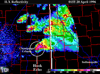 |
It's important to remember, however, that a thunderstorm can spawn a tornado without revealing a hook-like appendage. In some cases, the tornado may have been on the ground for some time before the hook echo ever appeared. Doppler radar is also useful in finding the rotating winds of mesocyclones. A mesocyclone is a column of spinning air 5 to 10 kilometers across and a precursor to the development of a tornado.
 |
Roughly 95 percent of all mesocyclones produce severe weather while approximately 30 percent result in tornadoes. Mesocyclones have a distinct signature on Doppler radar images, for example in the panel above. The mesocyclone is shown here as the abrupt change in pixel color from red to blue, indicating a sharp change in wind direction over a very short distance. If a tornado develops out of a particular mesocyclone, the time between the initial mesocyclone identification and a tornado touchdown is roughly 20 minutes.
|
How It Happened |
|
jacksonville |