
|

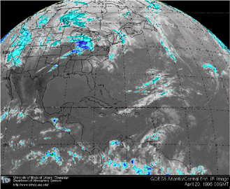 |
The list below provides access to satellite imagery prior to and during the severe weather outbreak. Visible images are available from 12Z April 19 to 00Z April 20, 1996. Infrared images are available from 16Z April 19 to 03Z April 20, 1996.
Visible Imagery
12z, 17, 18, 19, 20, 21, 22, 23, 00
/arch/cases/960419/data/sat/vis/96041912.gif)
/arch/cases/960419/data/sat/vis/96041917.gif)
/arch/cases/960419/data/sat/vis/96041918.gif)
/arch/cases/960419/data/sat/vis/96041919.gif)
/arch/cases/960419/data/sat/vis/96041920.gif)
/arch/cases/960419/data/sat/vis/96041921.gif)
/arch/cases/960419/data/sat/vis/96041922.gif)
/arch/cases/960419/data/sat/vis/96041923.gif)
/arch/cases/960419/data/sat/vis/96042000.gif)
Infrared Imagery
/arch/cases/960419/data/sat/ir/96041916.gif)
/arch/cases/960419/data/sat/ir/96041917.gif)
/arch/cases/960419/data/sat/ir/96041918.gif)
/arch/cases/960419/data/sat/ir/96041919.gif)
/arch/cases/960419/data/sat/ir/96041920.gif)
/arch/cases/960419/data/sat/ir/96041921.gif)
/arch/cases/960419/data/sat/ir/96041922.gif)
/arch/cases/960419/data/sat/ir/96041923.gif)
/arch/cases/960419/data/sat/ir/96042000.gif)
/arch/cases/960419/data/sat/ir/96042001.gif)
/arch/cases/960419/data/sat/ir/96042002.gif)
/arch/cases/960419/data/sat/ir/96042003.gif)
|
NEXRad Images |
|
surface |