
|


|
From The Developers...
Key words within the guide pages will be linked to other guide pages and concept helpers...allowing the user to access a wide variety of topics with just a few clicks. |
The diagram below shows a cyclone complete with warm and cold fronts. The cold front typically extends to the south from the center of low pressure while the warm front extends to the east (ahead of the storm). At low levels, several air masses of distinctly different origin may be found in varying parts of the cyclone. To the east of the cyclone, the moist air mass is moving to the north behind the warm front. The cold front marks the leading edge of a colder and drier air mass. Driven by counterclockwise winds around the center of low pressure (shown by the arrows), the cold air mass is dragged southward by north and westerly winds behind the low.
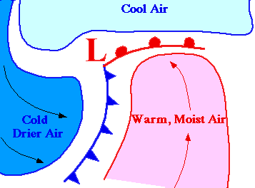
Clouds and precipitation often develop along and ahead of the cold front as the colder air mass lifts the warm moist air mass ahead of it.
|
precipitation |
|
Core Technologies |