
|


|
From The Developers...
This page provides a definition about cold fronts and how they are represented on weather maps. |
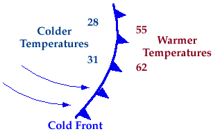
A cold front is defined as the transition zone where a cold air mass is replacing a warmer air mass. The air behind a cold front is colder and generally drier than the air ahead of it. In the picture below, temperatures ahead of the cold front are 55 and 62 degrees while behind the front temperatures are lower, 31 and 28.
If you were standing outside and a cold front passed through, the air would become cooler and drier than it was before. Occasionally, the temperature can drop as much as 15 degrees in an hour after a cold front comes through.
Symbolically a cold front is represented by a solid blue line with triangles along the front pointing towards warmer air. The triangles indicate the direction in which the front is moving. On most weather maps however, a cold front is represented by simply a solid blue line.
|
overview |
|
precipitation |