|
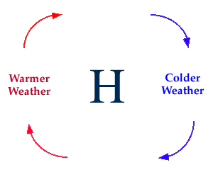
High and Low Pressure Centers
on forecasted temperatures
The positions of high and
low pressure centers can greatly
influence a forecast. Fair weather generally accompanies a
high pressure center and winds
flow clockwise around a high.
This means that winds on the back (western) side of the high are
generally from a southerly direction and typically mean warmer temperatures.
On the front (eastern) side of a high, winds are generally from the north and
this typically results in colder temperatures.
Forecast Tip:
If a city is expected to be located west of a
high pressure center
then warmer temperatures are likely. However, if the city
is expected to be in the northerly winds of a high pressure center, then
forecast colder temperatures. Cities under the influence of high pressure
centers can expect generally fair weather with little or no precipitation.
In contrast, clouds and precipitation generally accompany a
low pressure center and winds flow
counterclockwise around lows.
This means that winds on the back (western) side of the low are
generally from a northerly direction and typically mean colder temperatures.
On the front (eastern) side of a low, winds are generally from the south and
this typically results in warmer temperatures.
Forecast Tip:
If a city is expected to be located west of a
low pressure center
then colder temperatures are likely. However, if the city
is expected to be in the southerly winds of a high pressure center, then
forecast warmer temperatures. Cities under the influence of low pressure
centers can expect generally cloudy conditions with precipitation.

cloud cover
|
|

temp advection
|
|