
|


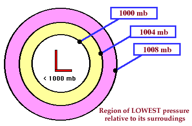
A surface low pressure center is where the pressure has been measured to be the lowest relative to its surroundings. That means, moving any horizontal direction away from the Low will result in increasing pressure. Low pressure centers often represent the centers of midlatitude cyclones.
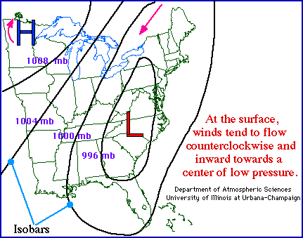
A low pressure center
is represented on a weather map by a red L.
Winds flow counterclockwise
around the low in the northern hemisphere.
The opposite is true in the southern hemisphere, where
winds flow
clockwise around an area of low pressure.
The counterclockwise winds associated with northern hemisphere
midlatitude cyclones play
a significant role in the movement air masses,
typically transporting warm moist air northward ahead of a low while
dragging colder and drier air southward behind it.
** Press "Reload" to restart the animation **
Rising air in the vicinity of a low pressure center
favors the development of clouds and precipitation,
which is why cloudy weather (and likely precipitation)
are commonly associated with an area of low pressure.
Cyclones are easily identifiable on certain types of weather maps by remembering
some key signatures.
For example, a cyclone
can be found on a map of surface observations by recognizing a
counterclockwise rotation of the wind barbs
for a group of stations, while on satellite
images, cyclones are identifiable by the trademark
comma shaped configuration of cloud bands.
|