
|


Forecast Tip:
If a dryline is approaching your region, predict that air will
be much drier after the boundary moves through. Storms are possible as the
dryline approaches.
The temperature may rise after the dryline passes through, since
dry air heats up more quickly than moist air.
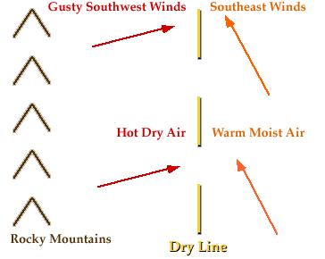
A dryline is a boundary that separates a moist air mass from a dry air mass. A dryline is also called a Dew Point Front. Sharp changes in dew point temperature can be found across a dryline (sometimes 9 degrees Celsius per kilometer). Drylines are most commonly found just east of the Rocky Mountains, separating a warm, moist air mass to the east from a hot, dry air mass to the west (see diagram below).
States like Texas, New Mexico,
Oklahoma, Kansas, and Nebraska frequently experience
drylines in the spring and summer, while east of the Mississippi
River, drylines are extremely rare.
The dryline is represented on surface maps by a dashed yellow
line (see example below).

Dew
points east of the dryline shown above range from the
upper 50's to low 70's, with
winds from the southeast.
West of the dryline, dew points are much lower, in the
20's and 30's, which is almost 50 degrees less than those
found east of the dryline.
Air temperature ahead of the dryline is generally in the 70's and 80's. Behind the dryline, temperatures are hotter, ranging from the mid 80's to mid 90's. The drier air behind the dryline lifts the moist air ahead of it as it advances, which could lead to the development of thunderstorms along and ahead of the dryline in a manner similar to how thunderstorms develop along cold fronts.
|
occluded fronts |
|
Temperatures |