
|


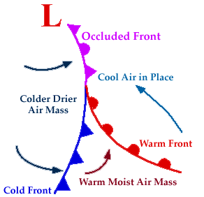
An occluded front develops when a cold front catches a warm front. For a maturing cyclone, a warm front is progressing northward ahead of the storm center while a cold front is sweeping southeastward. The cool air mass north of the warm front is already in place.
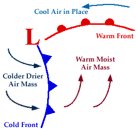
As the storm intensifies, the cold front rotates around the storm and catches the warm front. This forms an occluded front, which is the boundary that separates the new cold air mass (to the west) from the older cool air mass already in place north of the warm front. Symbolically, an occluded front is represented by a solid line with alternating triangles and circles pointing the direction the front is moving. On colored weather maps, an occluded front is drawn with a solid purple line.
Ahead of the occluded front, temperatures were reported in the low 40's, while temperaturesbehind the front were in the 20's and 30's. The air mass behind the front is also drier as shown by the lower dew points. Wind direction reports to the east of the front are from the east or southeast, while winds behind the front are from the west or southwest. Convergence of the easterly winds ahead of the occluded front and the westerly winds behind it can result in showers of rain or snow.
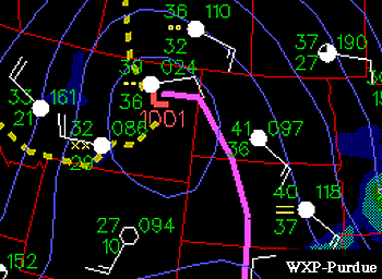
Image by: WXP Purdue
With the passage of an occluded front, weather conditions will likely turn from cool to cold. Winds will swing around from easterly to westerly or southwesterly with rain or snow showers possible, (depending upon how cold the temperatures are).
|
stationary fronts |
|
dry lines |