
|


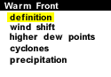
A warm front is defined as the transition zone where a warm air mass is replacing a cold air mass. Warm fronts generally move from southwest to northeast and the air behind a warm front is warmer and more moist than the air ahead of it. When a warm front passes through, the air becomes noticeably warmer and more humid than it was before.
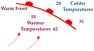
Symbolically, a warm front is represented by a solid line with semicircles pointing towards the colder air and in the direction of movement. On colored weather maps, a warm front is drawn with a solid red line.
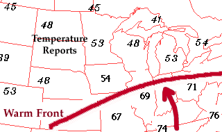
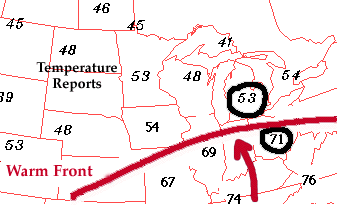
There is typically a noticeable temperature change from one side of the warm front to the other. In the map of surface temperatures below, the station north of the front reported a temperature of 53 degrees Fahrenheit while a short distance behind the front, the temperature increased to 71 degrees. An abrupt temperature change over a short distance is a good indication that a front is located somewhere in between.
If warmer air is replacing colder air, then the front should be analyzed as a warm front. If colder air is replacing warmer air, then the front should be analyzed as a cold front. Common characteristics associated with warm fronts have been listed in the table below.
| Before Passing | While Passing | After Passing | ||||
|---|---|---|---|---|---|---|
| Winds | south-southeast | variable | south-southwest | |||
| Temperature | cool-cold, slow warming | steady rise | warmer, then steady | |||
| Pressure | usually falling | leveling off | slight rise, followed by fall | |||
| Clouds | in this order: Ci, Cs, As, Ns, St, and fog; occasionally Cb in summer | stratus-type | clearing with scattered Sc; occasionally Cb in summer | |||
| Precipitation | light-to-moderate rain, snow, sleet, or drizzle | drizzle or none | usually none, sometimes light rain or showers | |||
| Visibility | poor | poor, but improving | fair in haze | |||
| Dew Point | steady rise | steady | rise, then steady |
|
Cold Front |
|
wind shift |