
|


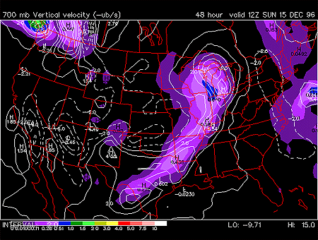
This panel shows the forecasted fields for 700 mb vertical velocities and quantitative precipitation. 700 mb charts depict conditions in the middle troposphere (roughly 3000 meters). This is also referred to as the steering level, since most weather systems are "steered" by the winds at this level.
700 mb vertical velocity is simply the velocity of air moving through the 700 mb surface in a vertical direction. Upward motion has a positive velocity (solid white contours) and downward motion has a negative velocity (dashed white contours). The vertical velocity field is given in millibars per second with an interval of 2 millibars per second between velocity contours.
Quantitative precipitation is represented by the color filled regions and the associated values are indicated by the color code located in the lower left corner of the forecast panel. Precipitation totals are given in inches with totals of less than 0.51 inches shaded in purple with heavier totals shaded in green, yellow and red. Quantitative precipitation is the estimation of the liquid equivalent precipitation that would occur during the 12 hour period. For example, quantitative precipitation fields for 0000Z 24 March 1996 represent the amount of precipitation that is predicted to occur from 1200Z 23 March to 0000Z 24 March 1996.
In this particular image, the important feature is the line of quantitative precipitation extending from Wisconsin southwestward into Arkansas and Texas. This line of precipitation is likely caused by a cold front. The vertical velocity is maximized further east of the quantitative precipitation maxima. This means that the areas of precipitation should move eastward with the advancing cold front.
Precipitation is a result of rising air and in regions where values of vertical velocity is greater than 5 mb/second, precipitation is likely to occur. Generally the areas of strongest precipitation are associated with the strongest upward motion. It is important to note that the quantitative precipitation field is depicts precipitation that has fallen in the past 12 hours. The vertical velocity field is valid for the time shown in the image. Therefore, the upward motion shows where precipitation is forming or will likely form in the near future and where precipitation will likely move. Downward motion, however, tends to suppress vertical development of clouds and precipitation, resulting in fair weather conditions.
|
700 hghts, humidity |
|
850 hghts, humidity |