|
|
. |
Role of Fronts
in the development of freezing rain
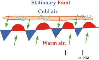
Stationary fronts can be
associated with the production of freezing rain.
A stationary front separates cold air to the
north from warm moist air to the south. Freezing rain develops as
upper-level winds (typically
light and southwesterly) push warm moist air over the colder air north of the
stationary front, producing a narrow band of freezing rain on the cold side
of the frontal boundary.
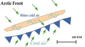
Arctic air masses are typically very shallow and have been known to
produce devastating ice storms.
Behind a cold front,
the air mass is maritime polar (mP), but behind an
Arctic front, the air mass
is continental polar (cP).
As Arctic air advances, it lifts the
warm moist air (ahead of the front),
producing precipitation that falls into the Arctic air.
Sometimes, a band of freezing rain wider than 50 kilometers
develops in association with an Arctic front.
|