|
|
. |
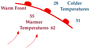
Warm Front
transition zone from cold air to warm air
A warm front is defined as the transition zone where a warm air mass
is replacing a cold air mass. Warm fronts generally move from southwest to
northeast and the air behind a warm front is
warmer and more moist than the air ahead of it.
When a warm front passes through, the air becomes noticeably warmer and more
humid than it was before.

Symbolically, a warm front is represented by a solid line with
semicircles pointing towards the colder air and in the
direction of movement. On colored weather maps, a warm front
is drawn with a solid red line.
|
