|
Introduction:
A cyclone is an area of low pressure around which the winds flow
counterclockwise in the northern hemisphere. Winds associated with
midlatitude cyclones transport heat and moisture from the tropics to higher
latitudes and these air masses typically clash in the middle latitudes,
often producing clouds and precipitation.
The purpose of this activity is to introduce the characteristics of
cyclones, the associated air masses and fronts, and finally how to locate
the center of a cyclone from wind observations. Key words
throughout this activity link directly to helper resources that provide
useful information for answering the questions.
Common Characteristics of Cyclones:
1) Complete the following sentence: A cyclone is
also is known as a _______________________________.
2) How is the center of a cyclone
labeled on a weather map?
3) Describe the
weather conditions
that typically accompany a cyclone.
4) Describe how
a midlatitude
cyclone appears on a satellite image.
Associated Air Masses and Fronts:
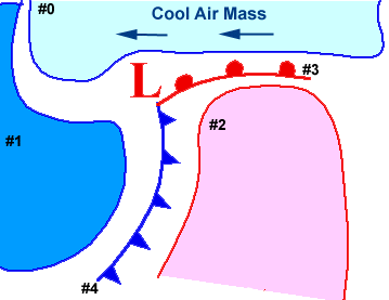
5) The diagram below depicts a model cyclone with associated fronts and
air masses. Answer the following questions by labeling the diagram
itself. You may label the diagram
in one of two ways; 1) by printing out a copy of this activity and marking your
answers directly onto the printout or 2) by saving the image into your favorite
graphics software and modifying the image using that graphics package.
- Circle the center of the cyclone
- Label air mass #1 and air mass #2 (as was done for air mass #0)
- Label the types of fronts represented by front #3 and front #4
6) Describe the general wind pattern associated with cyclones.
Storm Tracking:
7) For each of the following three surface maps, (Map #1, Map #2, and
Map #3), use the
wind barbs to
determine the location of the
cyclone center. Mark its
position on the blank map for each map, using the correct
symbol to represent the center of a cyclone.
For each position, also indicate the date and time.
| Map #1 | Map #2 | Map #3 |
/guides/crclm/act/gifs/cyc2.gif)
/guides/crclm/act/gifs/cyc3.gif)
/guides/crclm/act/gifs/cyc4.gif)
8) What was the cyclone's general direction of movement?
9) In what state was the storm located in for map #1? What about
maps #2 and #3?
Find the Current Cyclones:
10) To apply what you have learned to real-time weather data, go to the
Weather Visualizer
(
CoVis
version |
public
version)
and create a map of the latest surface observations.
From this map,
identify the position of any midlatitude cyclones
that may be influencing the weather in the United States.
You may label the diagram in one of two ways; 1) by printing out a copy of this activity and marking your answers directly onto the printout or 2) by saving the image into your favorite graphics software and modifying the image using that graphics package. If the Weather Visualizer is too busy, here are additional web sites for accessing current weather data.
- WXP Purdue
- Ohio State University
- Northern Illinois University
- University Corporation of Atmospheric Research
|