|
|
. |
Cold Front
transition zone from warm air to cold air
A cold front is defined as the transition zone where a
cold air mass
is replacing a warmer air mass.
Cold fronts generally move from northwest to southeast.
The air behind a cold front is noticeably colder
and drier than the air ahead of it.
When a cold front passes through,
temperatures can drop more than 15 degrees within the first hour.

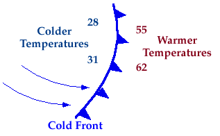
Symbolically, a cold front is represented by a solid line with
triangles along the front pointing
towards the warmer air and in the direction of movement.
On colored weather maps,
a cold front is drawn with a solid blue line.
|
