
|

In most cases, freezing rain results from the process of warm moist air "overrunning" colder air. Perhaps the most common overrunning scenario occurs as warm moist air flows up and over a warm front associated with a midlatitude cyclone. The rising air cools, the water vapor condenses, producing a narrow band of freezing rain ahead of the front. This band is typically less than 50 kilometers (30 miles) wide and is represented by region #1 (shaded in orange) in the diagram below. This band is often wrapped around and behind the low pressure center by counterclockwise winds flowing around the cyclone. Some of the most devastating ice storms occur in association with this narrow band of freezing rain.
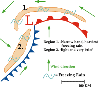
A second area of freezing rain is typically found behind the cold front, (region #2 shaded in orange in the diagram above). Freezing rain develops as southerly winds at upper levels push warm moist air up and over the cold front, producing precipitation that falls into the colder air. Freezing rain associated with the cold front is usually very light and scattered, and in rare cases, even observed ahead of the front.
|