
|

The most important phenomena associated with severe convection are tornadoes. When a tornado is present, it is usually small enough that it fits within one or two beam widths. Depending upon the geometry of the beam, the distance of the tornado from the radar, and the location of the beam relative to the tornado, the strong winds of the tornado will typically occupy one or two pixels. Adjacent pixels will have sharply different velocities, typically with one inbound and one outbound. In the picture below, the mesocyclone and tornado are in the middle of the radar beam so that the gray zero Doppler velocity band separates the two halves of the display.
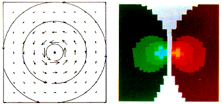
Image by: Brown & Wood
Doppler radars have a limited range of radial velocities that they can observe. Velocities beyond that range will be "folded" back into that range such that a strong outbound velocity, just beyond the observable range, will be interpreted as a strong inbound velocity within the observable range. Oftentimes the winds will be so strong in a tornado that the velocities observed by the radar will be folded in the pixel containing the tornado. Tornado Vortex Signatures (TVS) take on different characteristics depending on the geometry and whether or not the velocities are folded.
|