
|

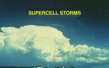
The last of the four major storm types is the supercell. We define a supercell as a thunderstorm with a deep rotating updraft (mesocyclone). In fact, the major difference between supercell and multicell storms is the element of rotation in supercells. As we shall see, circumstances keep some supercells from producing tornadoes, even with the presence of a mesocyclone.
Photograph by: Moller
Even though it is the rarest of storm types, the supercell is the most dangerous because of the extreme weather generated. This storm was producing baseball hail east of Carnegie, Oklahoma, as it was photographed looking east from 30 miles. From right to left (south to north), we note the flanking line, main Cb, and downwind anvil above the precipitation area.
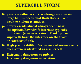 |
The flanking line of the supercell behaves differently than that of the multicell cluster storm, in that updraft elements usually merge into the main rotating updraft and then explode vertically, rather than develop into separate and competing thunderstorm cells. In effect, the flanking updrafts "feed" the supercell updraft, rather than compete with it. |
|