
|

Introduction:
Routine surface meteorological observations are represented on
weather maps by a standard notation of symbols and numbers.
In order to correctly interpret the data, it is important
to understand what types of data the different numbers and symbols
represent. This skill is not only important for
reporting weather conditions for a given station, but also for determining
the positions of significant meteorological features like fronts, cyclones
and anticyclones.
The purpose of this activity is to introduce these reporting symbols
and how to extract information about temperature, dew point temperature,
wind speed and direction, cloud cover, pressure and current weather. Key words
throughout this activity link directly to helper resources that provide
useful information for answering the questions.
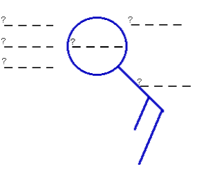
Components of the Observation Symbol:
1) Fill in the blanks of the diagram to indicate what type of
meteorological data is represented by each location.
You may label the diagram
in one of two ways; 1) by printing out a copy of this activity and marking your
answers directly onto the printout or 2) by saving the image into your favorite
graphics software and modifying the image using that graphics package.
Reporting on Weather Conditions:
Use the map of surface observations to answer the following questions.
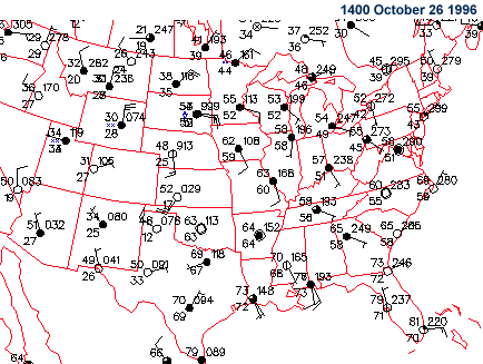
2) What is the temperature
in Des Moines, Iowa?
3) What is the dew point
temperature in Phoenix, Arizona?
4) What is the pressure
in Dallas, Texas?
5) What is the report of cloud cover in
Chicago, Illinois?
6) What is the report of
current weather (weather symbol) in Casper, Wyoming?
7) What is the speed and
direction of the wind in Miami, Florida?
Reporting Current Weather Conditions:
8) Now apply what you have learned to real-time weather data. Go to the
Weather Visualizer
(
CoVis
version |
public
version)
and create the latest map of surface observations.
For the station closest to where you live,
list the latest observations for
temperature, dew point
temperature, cloud cover,
pressure, current weather,
wind direction and
speed.
If the Weather Visualizer is too busy, here are additional web sites for accessing current weather data.
- WXP Purdue
- Ohio State University
- Northern Illinois University
- University Corporation of Atmospheric Research
|