|
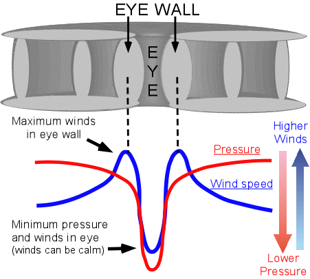
Atmospheric pressure and wind speed change across the diameter of a hurricane. To demonstrate, the diagram below shows a rough profile of wind speed (blue) and surface pressure (red) across a hurricane. Between 100-200 kilometers from the eye, the winds are fast enough to qualify as tropical storm force. The atmospheric pressure here will still be relatively high compared to the storm's center at about 990ş1010 millibars. However, the pressure gradually falls and the wind speed rises upon getting closer to the eye wall. It is only over the last 50ş100 kilometers that the large changes in pressure and wind speed occur.

The pressure begins to fall more rapidly while the wind speed simultaneously increases. Within the eye wall, the wind speed reaches its maximum but within the eye, the winds become very light ş sometimes even calm. The surface pressure continues to drop through the eye wall and into the center of the eye, where the lowest pressure is found. Upon exiting the eye, the wind speed and pressure both increase rapidly. The wind speed again reaches a maximum in the opposite eye wall, and then quickly begins to decrease. The wind and pressure profiles inside a hurricane are roughly symmetrical, so a quick rise in winds and pressure through the eye wall followed by a slower increase in pressure and likewise decrease in wind speed would be expected.
|
