
|

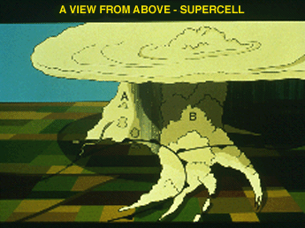
Looking northwest from above, an artist's view of a cyclic supercell portrays the rope stage of the dissipating tornado, and the rapidly weakening updraft (A) associated with it. At the same time, a new rotating updraft (B) is developing several miles to the east along the intersection of the RFD gust front and the stationary front (referred to as a pseudo-warm front). The juxtaposition of the intersecting gust fronts make this a highly favored area for formation of a new rotating updraft.
|