|

Surface Products:
|
Satellite Images:
|
On March 12, 1993, a newly formed
cyclone
moved into a low level baroclinic
zone already in place over the Gulf of Mexico and began to rapidly
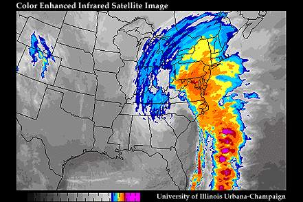
intensify. The deepening cyclone turned northeastward
(Fig 1.1) and the
center of low pressure
made landfall (Fig 1.2)
in northwestern Florida
during the early hours of March 13. An intense squall line
(Fig 1.3)
preceding a rapidly moving
cold front
raced across Florida with torrential
downpours, wind gusts in excess of 40 m/s,
3-4 meter storm surges and 11 confirmed tornado touchdowns
(Radar Loop (QT-800K)).
| Recorded Wind Gusts
Mount Washington, NH Franklin County, FL Dry Tortugas, FL Flattop Mountain, NC |
mph
144 110 109 101 |
m/s
64.4 49.1 48.7 45.2 |
Also by this time, widespread moderate to heavy snows extended from Alabama to New York (Fig 1.4), virtually paralyzing the eastern third of the country. An intense pressure gradient developed from the rapidly dropping central pressure (Fig 1.5), resulting in strong winds up and down the East Coast.
| Record Sea Level Pressures
White Plains, NY Philadelphia, PA New York, (JFK) Dover, DE |
Inches
28.28 28.43 28.43 28.45 |
mb
961.1 962.4 962.4 963.0 |
Fierce winds coupled with the heavy snow resulted in the cancellation of 25% of the nation's flights on Saturday and Sunday, interstates were impassable and millions were without power at one point in time or another during the passage of the storm.
| Recorded Snowfall Totals
Mt. Mitchell, NC Grantsville, MD Snowshoe, WV Syracuse, NY |
Inches
50 47 44 43 |
cm
128.0 120.3 112.6 110.1 |
More than a foot of snow fell from Alabama into Maine, combined with record cold in the storm's aftermath. Seventy record lows were set on March 14, with an additional 75 that following morning.
| Record Low Temperatures
Burlington, VT Mount LeConte, TN Asheville, NC Birmingham, AL |
F -12 -10 2 2 |
C -24.4 -23.3 -16.7 -16.7 |
When all was said and done, 270 people were dead and total property damage estimates exceeded $3 billion. According to the National Disaster Survey Report (NDSR 1994), twenty-six states were affected, impacting the lives of nearly 100 million people, approximately half the nation's population (Satellite Loop (QT-6M)).
For the classroom, online curriculum is available.
