|

|
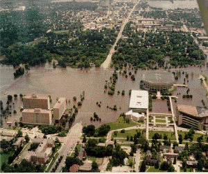
Midwest Flooding June-August 1993 During the summer of 1993, over 20 inches of rain fell upon many locations in the Midwest, with localized amounts exceeding 33 inches. The excessive amounts of rain severely affected shipping, agriculture, and human lives. This photo was taken in Ames, Iowa when the flood waters reached their maximum. |
An analysis of atmospheric conditions for the summer of 1993 showed a stationary high pressure system, also known as the Bermuda High, centered much closer to the United States than normally observed for that time of year. This allowed unusual amounts of warm moist air to be transported northward from the Gulf of Mexico and into the central portion of the country. This moisture-rich air fueled showers and thunderstorms that brought significant amounts of rain to many regions of the Midwest. Precipitation totals were so large and of such extended duration that normal means of surface water removal (transpiration, groundwater, and runoff) were inadequate. Rivers doubled, even quadrupled in size, as nearby towns succumbed to the floodwaters.
|
