
|


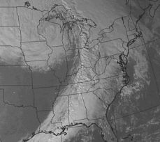
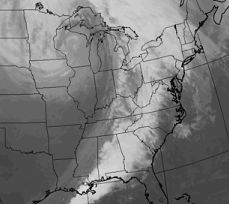
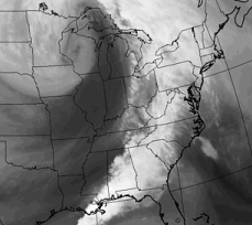
Images (a), (b) and (c) are examples of visible and infrared and water vapor satellite images respectively (valid for the same time).
|
The visible image depicts clouds stretching from the Gulf of Mexico northeastward into Canada. | |
|
The clouds over Louisiana, Mississippi, and western Tennessee appear gray in the infrared image because of their low and relatively warm cloud tops. The warmer the cloud top temperature, the darker the color. | |
|
These clouds are associated with a large area of moist air covering most of the eastern third of the United States visible in the water vapor image as the extensive area of white. |
The thunderstorms (areas of bright white) that broke out from Mississippi to South Carolina stand out more vividly in the infrared and water vapor images than in the visible. Drier air filtering in behind the thunderstorms across Illinois, Indiana and Missouri stands out very well in the water vapor image (c), however is not as noticeable in the infrared (b) and visible (a) images.
|
water vapor (wv) |
|
Reading Maps |