
|


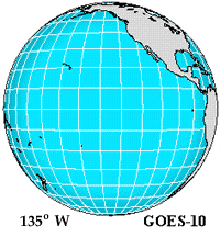
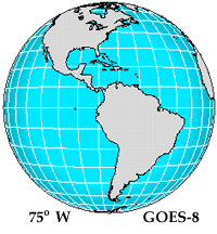
Geostationary Operational Environmental Satellites (GOES) circle the Earth in a geosynchronous orbit over the equator. This means they observe the Earth from the exact same place all the time. This allows the GOES satellites to continuously monitor a single position on the earth's surface. From 35,800 kilometers (22,300 miles) above the earth, GOES satellites provide half-hourly observations of the earth and its environment. Earth coverage of the GOES-8 and GOES-10 satellites has been depicted below.
 |
 |
| Images provided by: Satellite Coverages and Orbits (NCAR) | |
GOES satellites are owned and operated by the National Oceanic and Atmospheric Administration (NOAA) while the National Aeronautics and Space Administration (NASA) manages the design, development and launch of the spacecraft. Once launched, NOAA once again resumes responsibility for the satellites. There are other geostationary satellites operated by other countries wihich contribute to cover the rest of the Earth.
The first geostationary weather satellite (GOES-1) was launched on October 16, 1975 and quickly became a critical part of the National Weather Service operations. For the past 30 years, environmental service agencies have stated the need for continuous, dependable, timely, and high-quality observations of the earth and its environment. The new generation of GOES satellites, do just that. These satellites have instruments on board that measure Earth-emitted and reflected radiation from which atmospheric temperature, winds, moisture and cloud cover can be derived. GOES-8 and GOES-9 were the first members of this new satellite generation to be launched, replacing the older GOES-6 and GOES-7 orbiters.
 |
The GOES data, which is vital to weather monitoring and short-term forecasting, is then distributed by the National Environmental Satellite and Information Service (NESDIS) to a variety of operational and research centers. Today, GOES data products are used by a wide variety of users; the National Weather Service, commercial weather services, universities, the Department of Defense, and the global research community. |
Selected Text and Image Provided By: GOES Mission Overview
|
Satellites |
|
history of GOES |