
|


Echo top data is indicated by the small white numbers located near some of the radar echoes. These numbers are estimates in feet of the highest cloud tops associated with the radar echoes. Two zeroes must be added onto the end of each number to obtain a correct value. For example, in the lower left corner of the image, the value "200" associated with radar echoes just off the coast of Texas indicates that the highest cloud tops associated with these echoes to be approximately 20000 feet.
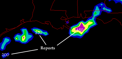
This information is typically useful because the higher the cloud tops,
the more intense the precipitation.
The 20000 foot cloud tops mentioned earlier were associated with
lighter precipitation
while southeast of Louisiana,
cloud tops approached 45000 feet near the
pink radar echoes
(indicating heavier precipitation).
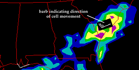
Cell movement data depicts in which direction and at what speed individual thunderstorm cells are moving. This information is indicated by a white wind barb (see example below). The white wind barb in South Carolina indicates that the individual cells embedded in the cluster of showers and thunderstorms along the East Coast are moving to the northeast at 25 MPH.
Area Movement indicates
the direction and speed of the entire line
or batch of precipitation.
Cell Movement indicates the movement of
individual cells
embedded in that larger area of precipitation.
|