
|


The word radar stands for Radio Detection and Ranging and radar images are useful for locating precipitation. As an X-ray machine examines the inside of a human body, a radar examines the inside of a cloud. A radar sends out signals into the atmosphere and if any precipitation is present, the radar signal is scattered back to the radar transmitter. These returned signals, called radar echoes, are used to produce radar images.
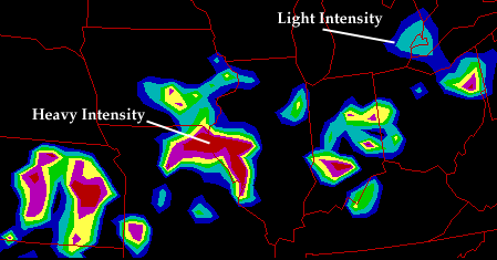
The location of the colored radar echoes
indicate where precipitation is falling
and the various colors indicate the intensity of the precipitation
through the color code in the legend below.
Shades of blue represent lighter precipitation while
red and purple indicate heavier precipitation.
The example radar image above shows extensive precipitation
from Kansas into Ohio
associated with showers and thunderstorms
that developed during the
late afternoon hours of August 15, 1995.
Regions of light and dark blue
indicate regions of lighter precipitation while areas of red and
purple indicate strong, to occasionally severe thunderstorms.
These radar images DO NOT specify precipitation type, as is seen with some newer products, only the location of precipitation and its intensity. Therefore, dark blue could represent either light rain or light snow, depending upon the weather conditions that existed at the time the radar image was generated.
|