
|


Hurricanes show up clearly on radar as circular areas of moderate to high reflectivity, often surrounding a low reflectivity center.
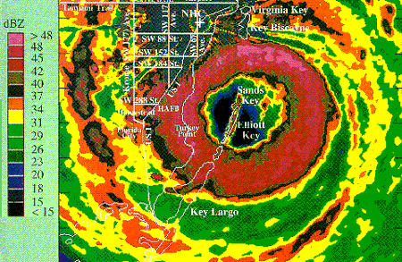
Image by: NHC
This image shows the reflectivity field from the eye wall of Hurricane Andrew. The symmetry shown in this image indicates that Andrew was a very well developed hurricane. The ring of orange are the high reflectivities associated with the convection found in the eye wall.

This image shows the reflectivity field from a scan of Hurricane Erin on August 2, 1995. The lack of symmetry indicates that Erin was a rather weak hurricane, especially compared to Andrew.

The velocity field of Hurricane Erin reveals the strong counterclockwise rotation responsible for the inward flow on the storm's north side and the outward flow on the south side. Negative values (blue-green) denote movement toward the radar and positive values (yellow-red) represent movement away from the radar.

Image by: NWS
This image shows the reflectivity field from a scan of hurricane Roxanne on October 19, 1994. High reflectivities north and east of the eye are associated with strong convection present in the eye wall.
|
tornadoes |
|
forecasting |