
|


This image shows a map of radar-estimated precipitation totals for a 12 hour period. Since the radar reflectivity is closely related to the precipitation rate, the total amount of precipitation falling on a region over a fixed period of time can be determined by analyzing reflectivity field over that period.
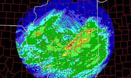
The heaviest amounts are indicated in yellow and red. Flash flood warnings would be issued for the stream and river basins which drain these areas.
|
forecasting |
|
snow storms |