|
The upper sequence depicts the life cycle of a non-severe single cell storm in weak wind shear, with white cloud shapes and gray shades of progressively heavier radar reflectivity. Note the quick collapse of the rainy downdraft through the updraft. The bottom sequence depicts the radar history of the severe pulse storm. Note that the initial radar echo in the pulse storm develops at higher levels than in the non-severe single cell storms. Stronger radar reflectivities aloft with the pulse storm cascade down, resulting in a quick burst of severe weather, possibly hail but more likely downbursts, just before storm dissipation.
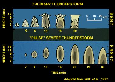
Although both non-severe and severe single cell storms typically occur in weakly-sheared, summer atmospheres, the pulse storm usually occurs in a more unstable environment. Its stronger updraft allows for a slightly longer lifetime. Severe storm radar detection methods such as the Lemon Technique, developed for vertically-sheared environments, will not work very well with pulse storms. The exception to this is the case where the radar operator detects unusually strong mid-level reflectivities prior to updraft collapse.
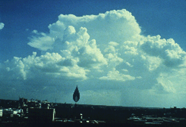
Photograph by: Moller
This is another single cell storm with tops near 40,000 feet, but on a day with virtually no vertical wind shear. Contrast the height of the cloud base with that in the previous photo. This storm had a much higher base, about 1/5 of the way to the storm top, or approximately 8,000 feet above the ground. The temperature and dew point temperature on this August day were 102 and 61, respectively. The low-based storm in the previous photo occurred with values of 94 and 74.
Storms that occur with 30 to 50 degree surface temperature/dew point spreads have relatively high microburst potential. (This is not to say that environments without such huge spreads will not produce microbursts!) This combination of surface observations and high-based Cbs should serve as "red flags" to pilots and aviation weather forecasters. Several short-lived storms that occurred in the Fort Worth area on this day produced microbursts.

introduction |
|

Multicell Clusters |
