
|


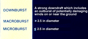
Damaging thunderstorm winds have been termed downbursts by renowned severe storm researcher Dr. Ted Fujita. Dr. Fujita further classifies these events as macrobursts (greater than 2.5 miles in diameter) and microbursts (less than 2.5 miles in diameter).
Generally, a macroburst is on the scale of the entire cold air outflow field of a thunderstorm or a group of thunderstorms; whereas the microburst is a sub-thunderstorm scale outflow feature. This is a southward view from within one mile of a microburst embedded within a macroburst.
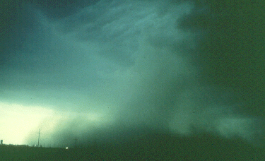
Photograph by: Moller
The transition line from ragged to smooth cloud texture, to the left and above the microburst, is where the right to left-advancing macroburst meets cloud base. This is the leading edge of the thunderstorm gust front ahead of a line of thunderstorms. Immediately behind the gust front and to the right side of the highway, the microburst has reached ground and is in the process of "curling" over the highway. Estimated wind speeds from moving dust parcels were 70 MPH. We will have more on the visual identification of microbursts later.
|
outflow |
|
tornadoes |