
|


As the multicell storm becomes severe, the stronger updraft becomes more vertical and the top shifts upwind over a tightening low-level reflectivity gradient on the updraft storm flank. This transformation is not the same updraft becoming more erect with time, but a new flanking line tower that is more powerful than earlier updrafts.
 |
The precipitation downwind of the updraft
becomes heavier, with moderately
large hail
(marble to golf ball size) falling near the updraft. Size
separation of precipitation accounts for the increased
VIP level gradient, with
the lightest elements being blown the greatest downwind distance.
Tightening VIP gradient, shift in Cb top position, and development of mid-level echo overhang above a low-level weak echo region (WER) are all strong indicators of an intensifying updraft and increasing severe potential. As this intensification process proceeds, the strongest downbursts often shift from near the leading or east storm quadrant to near the southwest storm flank. This, in turn, enhances fresh convective development along the flanking line. |
The same Texas Panhandle storm has intensified to the severe multicell stage at this time. The tower that was on the middle-back side of the flank in the previous photograph has developed vigorously and become much more vertical than its predecessors.
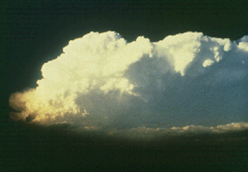
Photograph by: Marshall
The rock-hard nature of both the Cb and the downwind anvil are visual clues as to the updraft's strength. The storm was a much larger VIP 5 on radar at this time with an increasingly tight VIP level gradient on the southwest flank.
|
lemon techique (LT) |
|
supercell lt-analysis |