
|


Still looking west from the same vantage point about 20 minutes later, the storm was moving off to the right (north) leaving a curving, weakening outflow boundary behind it. This boundary is visible as the darkest cloud base in the middle ground, arcing into the right background. Look to the right horizon. There is another rain area, and another cloud-base lowering to the south of the rain. Is this a repeat of what we have just observed? Note the subtle hint that the cloud is sloping into the rain area.
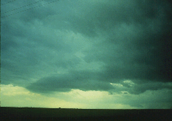
Photograph by: Doswell
The second storm is approaching, and the cloud lowering continues to slope into the precipitation. It is a wall cloud, exerting "pull" on the rain-cooled air and maintaining its distance from the visible precipitation shaft rather than being "pushed" away from it. We have witnessed the progression from severe multicell storm to supercell when a secondary updraft in the flanking line blossomed into a rotating updraft. This storm lasted for several hours after this stage, producing large hail and several weak tornadoes.
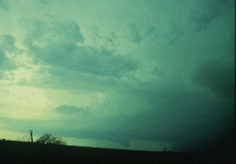
Photograph by: Doswell
A final word for spotters: when watching a potential wall cloud, have patience! Don't expect a quick tornado warning when you report the wall cloud, but watch for tornadic wall cloud characteristics. The forecaster and radar operator will also be scanning the storm for tornadic signatures.
|
visual clues |
|
Microbursts |