
|


Both extra-tropical and tropical cyclones, like this hurricane, can cause air to rise. This type of lifting is different from the lifting produced along frontal boundaries.
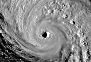
Image by: the GOES Project
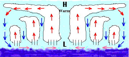
In hurricanes, condensation occurs through a process known as CISK (Convective Instability of the Second Kind). We will demonstrate CISK by referring to the animated cross-section through a mature hurricane given below. In CISK, surface convergence (pink horizontal arrows) causes rising motion around a surface cyclone (labeled as "L"). The air cools as it rises (red vertical arrows) and condensation occurs, which releases latent heat into the atmosphere. This heating causes air to expand, creating an area of high pressure aloft. The force resulting from the established pressure gradient causes air to diverge at upper levels (red horizontal arrows).
Animation by: Shao
Since pressure is a measure of the weight of the air above a unit area, removal of air at upper levels subsequently reduces pressure at the surface. A further reduction in surface pressure leads to increasing convergence (due to an intensified pressure gradient), which further intensifies the rising motion, latent heat release, and so on. Despite the absence of fronts, a tremendous amount of lifting occurs in hurricanes, with intense condensation leading to the development of deep clouds and heavy rainfall.
In extra-tropical cyclones, surface winds are deflected by friction towards the center of the low pressure system (red "L" below).
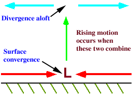
Coupled with divergence aloft, (blue arrows), surface convergence (red arrows) can generate rising motion (green arrow) that leads to the condensation of water vapor.
|
convection |
|
fronts |