|
Forecast Tip:
If there is sufficient moisture
in the air and a forcing mechanism like
a cold front
(for example) is approaching the area, then there is an
increased probability that precipitation will occur.
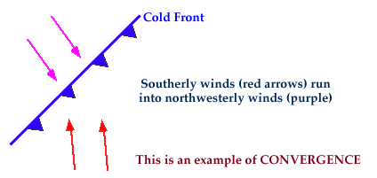
Clouds and precipitation are formed by the upward motion of air. Therefore, there must be a mechanism present to lift the air. Fronts often serve as such a mechanism. Air on one side of the front typically blows in a different direction from the wind on the other side, causing the air to converge, or pile up right along the frontal surface.

Since this air has to go somewhere, it rises.
As air rises, the moisture in the rising air cools, condenses and
forms clouds
and precipitation.
For example, a cold front
lifts warm moist air ahead of it as it advances.
The rising air cools and the water vapor condenses out to form
clouds, most commonly ahead of and along the
cold front
(diagram below).

As the cloud droplets grow in size, they begin to fall back to the earth
as precipitation.
Vigorous upward motions often occur ahead of and along a cold front,
resulting
in more vertically developed clouds like
cumulonimbus clouds,
which themselves can
produce heavy rains and powerful thunderstorms.
Forecast Tip:
If there is sufficient moisture
in the air and a forcing mechanism like
a cold front
(for example) is approaching the area, then there is an
increased probability that precipitation will occur.

Temperatures |
|

moisture |


