
|


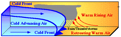
Lifting also occurs along frontal boundaries as air masses of different temperature and moisture content interact with eachother. For example, as the cold front advances (animation below), it lifts the warm moist air ahead of it. The rising air cools and the water vapor condenses out to form clouds, typically ahead of and along the cold front. Vigorous lifting often occurs along a cold front, resulting in more vertically developed clouds like cumulonimbus clouds.
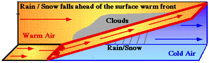
In contrast, lifting along a warm front
different than what takes place along a cold front.
As the warm front nudges against the colder,
denser air mass ahead of it, warmer air behind the surface front is forced
to ride up and over the frontal surface and over the colder air ahead of it.
The lifted air cools and the water vapor condenses out to form clouds
in advance of the surface warm front.
The lifting along a warm front is more gentle when compared with the
lifting along a cold front. Consequently, warm frontal clouds are more
widespread and less vertically developed. These clouds are occasionally
observed up to a thousand kilometers in advance of an approaching
warm front.
|