
|


When the earth is heated by the sun, bubbles of hot air, or thermals, rise up from the warm surface, cooling and expanding as they ascend. The thermal becomes diluted as it mixes with the surrounding air, loosing some of its buoyancy. Successive thermals following the same path usually rise higher than previous ones, and if a thermal is able to rise high enough to cool to its saturation point, the moisture within condenses and becomes visible as a cloud.
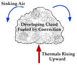
An air parcel will rise naturally if the air within the parcel is
warmer than the surrounding air (like a rising hot air balloon).
Therefore, if cool air is present aloft with warm air at
lower levels, thermals can rise freely to great heights
before loosing their buoyancy. When a deep stable layer exists just above
the cloud base, continued vertical growth is restricted and only
fair weather cumulus are able to form.
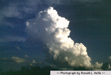
If a deep unstable layer exists just above the cloud base,
continued vertical growth is likely, possibly leading to the development of a
cumulonimbus cloud. However, once the supply
of thermals is cut off, the clouds begin to dissipate and eventually disappear.
In contrast to
convergence lifting, convective clouds are typically
much more vertically developed and are fueled by stronger
updrafts,
sometimes in exceeding 50 miles/hour in the more powerful thunderstorms.
|