
|


Stratocumulus clouds generally appear as a low, lumpy layer of clouds that that is often the spreading remains of much larger cumulonimbus clouds. They range in color from dark gray to light gray and can appear in rows, patches, or as rounded masses with breaks of clear sky in between.
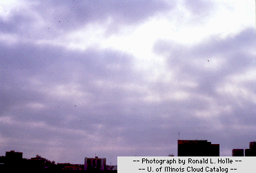
Rain or snow rarely fall from these clouds and they are different from
altocumulus clouds
since their individual elements are larger than those of their
altocumulus counterparts.
You can easily decipher between the two cloud types by holding your hand
at arm's length and pointing it towards the sky.
Altocumulus
elements are about the size of a thumb nail,
while stratocumulus are about the size of a fist.
Low clouds are almost always comprised of water droplets since their bases generally lie below 6500 feet (2000 meters). However, when temperatures are cold enough, these clouds may contain ice particles and snow.
|