
|


Reference Weather Map |
Current Weather Map |
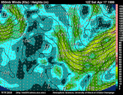
850 mb observed fields for geopotential height, wind speed and wind vectors. 850 mb charts depict conditions in the lower troposphere (roughly 1500 meters).
Geopotential height approximates the actual height of a pressure surface above mean sea-level and is represented by the solid white contours. The geopotential height field is given in meters with an interval of 30 meters between height lines. The locations of surface cyclones and anticyclones hold similar positions in the 850 mb geopotential height field.
Wind vectors provide information about wind direction and wind speed and are drawn here as arrows. Wind vectors point towards the direction in which the wind is blowing and the longer the wind vector, the stronger the wind. The unit of magnitude for wind speed as depicted by the wind vectors is meters per second.
Wind speed is represented by the color filled regions and the intensity is indicated by the color code located on the right side of the forecast panel. Wind speeds are given in knots with an interval of 2 knots between wind speed contours, also called isotachs. Wind speeds of less than 20 knots are represented by shades of blue while winds exceeding 50 knots are depicted in shades of red.
This information is useful in locating the low level jet, a narrow band of relatively strong winds that can be responsible for the strengthening of thunderstorms in the United States. These strong low level winds can push warm humid air from the Gulf of Mexico over land and create unstable regions where significant thunderstorms can develop. The closer together the height contours, the stronger the wind speed, which is why jet streaks are found where height contours are packed closely together.
|
850 mb hum,winds |
|
850 mb temps |