
|


Reference Weather Map |
Current Weather Map |
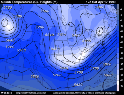
This panel shows the latest 500 mb fields for geopotential height, temperature and wind vectors. 500 mb charts depict conditions in the middle troposphere (roughly 5000 meters).
Geopotential height approximates the actual height of a pressure surface above mean sea-level and is represented by the solid white contours. The geopotential height field is given in meters with an interval of 60 meters between height lines. The 500 mb height field encircling the globe consists of a series of troughs and ridges, which are the upper air counterparts of surface cyclones and anticyclones. The distance from trough to trough (or ridge to ridge) is known as a long wave. Embedded within the long waves are short waves, which are smaller disturbances often responsible for triggering surface cyclone development.
Temperature is represented by the color filled regions and the associated values are indicated by the color code located in the lower left corner of the forecast panel. Temperatures are given in degrees Celsius with an interval of 5 degrees Celsius between temperature contours, also called isotherms.
Examination of the height and temperature fields reveal regions of cold advection (into a trough) and warm advection (into a ridge). These processes act to amplify the wave in the geopotential height field, intensifying vertical motions and providing energy for a developing cyclone.
|
500 mb vorticity |
|
700 mb humidity |