
|


A line connecting points of equal temperature
is called an isotherm. That means, at every point along a
given isotherm, the values of temperature are the same.
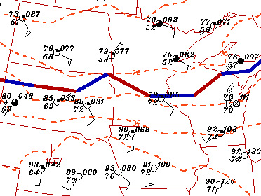
Isotherms are represented by dashed orange contours in the Weather
Visualizer. An image of surface temperature reports and
isotherms has been given below.
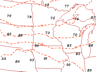
The black numbers are station reports of surface temperature in degrees Fahrenheit, which is the unit for temperature in the U.S.. Most other nations of the world use Celsius.
The isotherms displayed were generated from the observed values of temperature, and have been plotted at intervals of 5 degrees Fahrenheit. The small orange numbers are contour labels, which identify the value of an isotherm (75, 85 degrees Fahrenheit).
For example, reported temperature values in Nebraska, southern Iowa and Illinois are generally 90 or above, and are therefore located south of the 90 degree contour.
In the image below, this surface temperature information has been incorporated into a more complex surface map generated for the same time.
Reported temperatures show that a dome of very warm air has pushed its way into Nebraska, where temperatures are above 90. More pleasant weather is found across North Dakota and Minnesota, where temperatures are in the 70's.
|
wind & isobars |
|
isodrosotherms |