
|


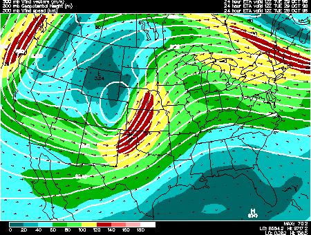
This panel shows the 300mb forecast fields for geopotential height, wind speed, and wind vectors. 300mb charts depict conditions in the upper portion of the troposphere (roughly 9000m) where most of the weather producing phenomena occur, otherwise known as the jet stream level.
Geopotential height approximates the actual height of a pressure surface above mean sea-level and is represented by the solid white contours. The geopotential height field is given in meters with an interval of 120 meters between height lines. The 300 mb height field encircling the globe consists of a series of troughs and ridges, which are the upper air counterparts of surface cyclones and anticyclones. The distance from trough to trough (or ridge to ridge) is known as the wavelength. Typically waves at 300mb are known as long waves. Embedded within the long waves are short waves, which are smaller disturbances often responsible for triggering surface cyclone development.
Wind vectors provide information about wind direction and wind speed and are drawn here as tiny red arrows. Wind vectors point towards the direction in which the wind is blowing and the longer the wind vector, the stronger the wind. The unit of magnitude for wind speed as depicted by the wind vectors is meters per second.
Wind speed is represented by the color filled regions and the intensity is indicated by the color code located in the lower left corner of the forecast panel. Wind speeds are given in knots with an interval of 20 knots between wind speed contours, also called isotachs. Wind speeds of less than 60 knots are represented by shades of blue while winds exceeding 120 knots are depicted in shades of red.
In this particular image, the most noteworthy features are the deep trough located over northern Colorado, and the associated jet streak whose axis runs from Texas northeastward into Nebraska. This trough and jet streak will spawn a surface cyclone over the Great Plains region.
This information is useful in locating the jet stream, a narrow band of relatively strong winds encircling the earth in the upper troposphere. Wind speed maxima embedded within the jet stream, called jet streaks, are localized regions of high atmospheric energy that play a vital role in the development of surface low pressure centers. At 300mb, the wind typically blows parallel to the height contours. Also, the closer together the height contours, the stronger the wind speed, which is why jet streaks are found where height contours are packed closely together.
|
Upper Air Maps |
|
300 hghts, temps |