
|


1)
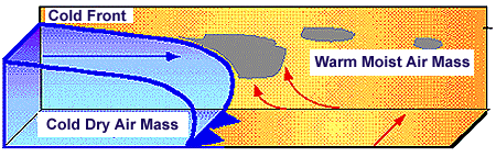
The cold air mass (in blue) is wedging into the warmer air (in yellow), lifting the less dense warmer air ahead of the front. The moisture in the warm air cools and condenses as its lifted, leading to the development of clouds and precipitation. Vigorous upward motion ahead of the front can lead to the development of intense showers and thunderstorms ahead of and along the front.
2)
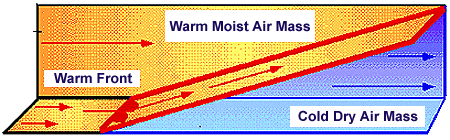
As the warm air nudges against the colder air mass ahead of it, the advancing warmer air is forced to rise up and over this colder denser air mass. The lifting is much gentler than commonly observed along a cold front, and consequently the resultant precipitation is steadier, more wide spread and not as heavy. Clouds and precipitation can be observed at least several hundred kilometers ahead of the surface warm front.
The slope of a warm front is much more gradual and this leads to gentler
upward motions. Precipitation along a warm front is typically more wide spread
and not as heavy, but more continuous.
Since the upward motions are somewhat weaker, the clouds are less
vertically developed than found along cold fronts.
The lifting occurs as the advancing warmer air nudges up against the
heavier colder air ahead of the front. Since the warm front slopes
towards the colder air with height, warmer air at lower levels rides up and
along the frontal surface (over the colder air mass below). Clouds and
precipitation can develop as far as 1000 km ahead of the surface warm front.
3)
The slope of a cold front is much steeper and this leads to more vigorous
lifting ahead of it.
The stronger the upward motions, generally the stronger continuous.
Since the upward motions are somewhat weaker, the clouds are less
vertically developed than found along cold fronts.
The lifting occurs as the advancing warmer air nudges up against the
heavier colder air ahead of the front. Since the warm front slopes
towards the colder air with height, warmer air at lower levels rides up and
along the frontal surface (over the colder air mass below). Clouds and
precipitation can develop as far as 1000 km ahead of the surface warm front.
|
air masses |
|
midlatitude cyclones |