
|


Data Collection:
The next step is to begin collecting data about this storm.
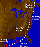
Storm Track |
Select three cities from the eastern United States, preferable choosing one on each side of the storm's path and a third directly in the path of the storm. |
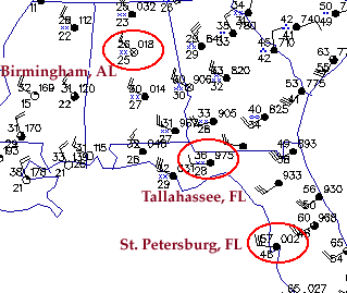
For each city, record the values of temperature, dew point temperature, winds and weather conditions. An example has been given below for a group of cities including Birmingham, AL (north of storm track), Tallahassee, FL (directly in path) and St. Petersburg, FL (south of storm track).
Example of Data Collection:
|
Access surface weather maps and record the reported observational data for each city in your group. For example, if you selected group #1, you'll record data for Birmingham, Tallahassee and St. Petersburg. However, in order to accurately collect and record the data, you need to be able to interpret observation symbols. If you need to learn how, complete the scaffolding activity below to ensure correct interpretation of the data.
Scaffolding Activity:
| Interpreting Surface Observation Symbols | Learn how variables like temperature, wind direction and pressure are represented on a weather map. |
This is an example of how the scaffolding activities can be used to help you complete your project accurately. An example of the data collection process is given below. The cities circled in red belong to Group #1; Birmingham, Tallahassee and St. Petersburg. For each city, the data for temperature, dew point temperature, winds and weather (or precipitation) have been recorded.
For the cities chosen, collect similar pieces of data during the time period beginning 1200Z 12 March and ending on 0900 14 March, 1993. Record the data at two hour intervals (every other hour). The surface maps are accessible in the SuperStorm '93 Archives.
There are four regional views of surface weather data and they include: Continental United States, Northeast, Middle Atlantic and Southeast. Select the region that allows the best view of the data for the cities you've chosen.
|
start up activity |
|
choosing a topic |