
|


1c. Directional Wind Shear:
Numerous studies have found a strong correlation between the strength of LES and the degree to which the wind changes direction with height in the lower atmosphere. Thus, the minimization of directional wind "shear" is considered to be an excellent predictor of LES snowfall rates and intensity. If winds line up in the vertical between the surface and the top of the mixed layer (and slightly above) the heat and moisture plumes generated at the lake surface remain focused and locally strong; conversely, directional shear in the same layer will advect the heat and moisture in different directions at different heights; this can diffuse the plumes by spreading the heat source horizontally and "differentially" through the vertical.
For some years now, Buffalo (and other NWSFO's in the Great Lakes) forecasters have used charts and computer programs which ingest current and predicted values of temperature, wind speed and direction, lake temperature, inversion height (these products are derived from observations and numerical prediciton model output) and produce LES predictions from a "nomogram" or chart which relates the known predictors of lake-effect against the current condition. In these operational settings, the directional shear between the surface and 700 mb is known to be a robust statistic. Below is a sample screen from a software tool used in the BUF forecast office called BUFKit.
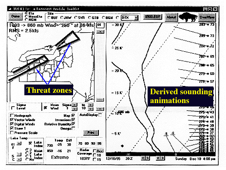
Image by: NWS Buffalo
Bufkit was written by Ed Mahoney and the forecast staff of NWSFO BUF.
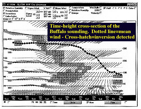
Today, it is possible to produce "derived" soundings from the operational numerical predictions models such as the NGM and the ETA. Whereas, actual soundings are only available twice daily from a limited number of reporting stations, derived soundings can be produced at any location and for any time within the span of the NWP model forecast (of course, the data is predicted and interpolated from the actual observations so it may vary significantly from what really occurs). Derived soundings can be animated in time which gives great insight into the evolution of the atmosphere above a given point. This is a useful method of determining the time rate of change of directional shear with height, stability, and height of any capping inversion. Forecasters often tailor their predictions of the timing and location of heavy LES based on the evolution of these parameters attaining their critical or threshhold value; e.g. directional shear of less than 20 or 30 degs between the surface and 700 mb is considered a threshhold for organized LES. A tool like BUFKit facilitates this type of analysis and greatly speeds-up and improves operational forecasting.
The image below shows 850 mb flow at 12z on 11/11/96. Compare this flow to surface flow and 500 mb air flow. There are increasing wind speeds as one moves upward from the surface but the shape of the flow - or wind direction - changes little with height as would be anticipated in this ideal LES set-up. Thus, analysis of multiple pressure surfaces is another means of evaluating wind shear in the vertical.

|
Stability |
|
QG Model |