
|


Examining Q-vectors for the period around Nov 11, 1996 shows only slight signal at low middle and high layers of the model. However, in the case of 11/10/96 when the short-wave was pivoting through the eastern lakes stronger Q-vector forcing is evident. The figure below shows Q-vectors and geopotential heights at 500 Mb on 11/10/96. The Q-vector plot suggest a confluence of strong Q-vectors from western New York through West Virginia with good convergence of Q in eastern Ohio. By theory, this forcing must indicate a thermally indirect transverse circulation since the Q-vectors point towards the cold air.
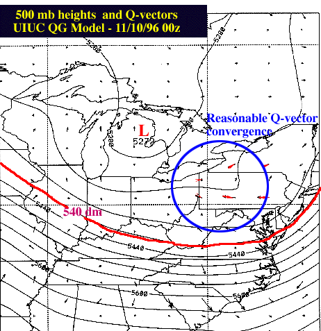
Indeed, the cold front in western PA weakened during this period as it aligned itself parallel to the upper level flow. In the model forecasts, the surface temperatures in NY and central PA were much too cold for the 12 - 24 period following 11/10/96 00Z, and lake-effect snow was predicted too early compared to the observed evolution. Here the Q-vectors give good insight into the region of best ascent found back in the cold air, as well as the frontolytic response to the indirect thermal circulation. Q-vector convergence verifies well with the area of heavy snowfall in NE Ohio - at least in this analysis.
|
QG Model |
|
Summary |